Choose the place and the species. The index, from 0 to 100, combines weather, sun, moon and tide with each fish's habits. Up to 28 days, with each day's confidence.
location
Sample location: choose yours to see the forecast for where you fish.
period
Reading the weather across 3 global models and 31 simulations…
0—
index Score from 0 to 100 for the fishing conditions of each hour. It reads weather, sun, moon, tide and the species' habits. It doesn't promise fish: it tells you when the water is on your side. 0–24 poor · 25–44 fair · 45–64 good · 65–84 very good · 85–100 excellent.
today
—
confidence —
confidence How much you can trust the weather forecast for the day. It drops with distance and when the models disagree. It is not the chance of catching fish.
models and trend Up to 16 days, three global weather models (the European ECMWF, the American GFS and a high-resolution blend) read hour by hour; when they disagree, the light band on the chart widens. Beyond that it's a trend: 31 runs of the American GEFS model. Confirm when it's 1 week out.
window Consecutive hours with the index near the day's peak and no danger alert. It is the time to have the bait in the water.
hour by hour
tap or drag on the chart to read each hour · on a keyboard, arrow keys
see hour-by-hour table
why this index at —?
next 7 days
choose the day
chart: bar height = day's index · line = variation between models · striped = trend · fainter = less confidence
Each card shows the day's index (0 to 100) and, below it, a strip with the index for each hour, from 0h to 23h. from poor to excellent.
4-week calendar
the fishing month at a glance
plan a trip
what's the best window for the crew?
Choose how many fishing days. We compare each stretch by its average index, discount days with a warning or closed season, and show the 3 best.
trend for the coming weeks
Line: the middle value of 31 simulations of the American GEFS model. Band: where 8 out of 10 fall. Narrow, firm trend; wide, high uncertainty.
the species
everything about the branquinha
overview
who is the branquinha
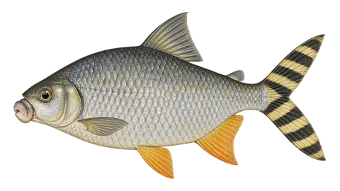
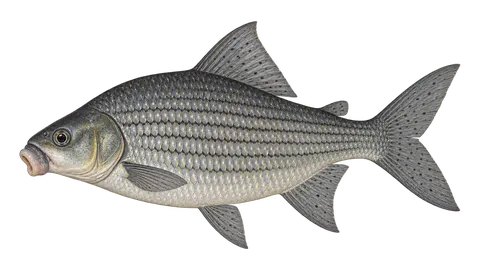
Branquinhas are fish of the family Curimatidae, which have no teeth and feed on detritus and on the film of algae and microorganisms from the bottom and vegetation. The common branquinha forms very large schools in the várzea lakes and whitewater rivers of the Amazon and migrates with the water cycle. Because of its abundance, it is the base of the food chain: peacock bass, arapaima, catfish and river dolphins (botos) eat branquinha. It also appears in large numbers at the Manaus and Santarém landings, caught in nets. It is rare on the hook.
fun facts
Curimatídeos have no teeth: they scrape food with their lips and filter the mud.
Because it is so abundant, the branquinha sustains much of the várzea's predators.
how to recognize it
identification
Tall, very compressed, silver body with a keeled belly. Small mouth, no teeth. Pale fins, without strong spots. The smooth-head branquinha (Potamorhina altamazonica) looks very similar. It does not have the sucker mouth of the jaraquí and curimatã.
It is a net fish. For live peacock bass bait, first check whether local rules allow it.
what the law says
rules for the branquinha
Summary of the regulations we found, with the source for each. Rules change; before keeping or transporting fish, check with the state environmental agency. Conservation: Not on the national list (Portaria GM/MMA 1.667/2026).
Amazonian closed season (AP)
catch, transport and sale prohibited (commercial fishing)15/11 to 15/03APAmazon
In AP the branquinha (Potamorhina latior and other branquinhas) is in Annex II of the ordinance, with fishing prohibited from Nov 15 to Mar 15. Under art. 2 of the ordinance, anglers fishing with a handline or pole, line and hook are exempt from this ban, unless a stricter state rule applies; during the period the angler's limit is 5 kg + 1 fish.
piracema closures in the basins where the species lives
Spawning closure (piracema) in Mato Grosso (all basins)
01/10 to 31/01MT
Allowed: All fishing modalities are prohibited in rivers, including catch and release (Law 9.096/2009, art. 19-A). Exceptions: subsistence fishing from shore (3 kg or 1 fish, no transport or sale) and scientific fishing. Law 13.159/2025 now allows licensed sport fishing in UHE/PCH hydropower reservoirs, natural lakes and border rivers, subject to a scientific study and a license from the environmental agency. We have not confirmed whether these licenses are already being issued.
Allowed: Recreational anglers with handline or rod, line and hook are outside the Annex II prohibitions, with a bag limit of 5 kg + 1 fish, unless a stricter state rule applies.
catch and release Releasing the fish alive, quickly and with a wet hand. During a closed season it isn't always allowed: what the regulation says applies.
Fragile fish: release it quickly, without squeezing.
in the kitchen
Fatty meat with bones; fried well done, with fine cuts.
calculator
how much it weighs without taking it out of the water
Length-weight relationship W = a·Lb (a = 0.01622, b = 3.0; FishBase). It's an average: a fat or lean fish can vary by 10% to 20%.
estimated weight
—
sources and references
The season weights (months), the time of day and the sensitivities (cold, pressure, moon, wind, rain, tide, strong light, murky water and noise) are the app's editorial estimates, based on the literature below and on the field experience of anglers and guides. They are not official data nor a measurement made for this species, and they may vary by region and year. Closed seasons and legal rules appear in the rules section, with the norm and a link.
The weather comes from three independent global models, cross-checked hour by hour: when they agree, confidence goes up; when they diverge, the band between them shows on the chart. Beyond 16 days, we use the GEFS ensemble of 31 simulations: if 20 of the 31 predict rain, the chance of rain is 65%. Sun and moon are calculated astronomically, with no uncertainty.
The index adds up, weighted for each species: time of day (species curve anchored to real sunrise and sunset), moon (transits, rise and set, phase), pressure (3 h trend and 24 h swing), water temperature (in rivers, estimated from air temperature; at sea, estimated by an ocean model), wind, rain, clouds, tide and the month in the species' cycle.
Accuracy measured in the reference project (4 regions, 93 days, forecast vs. observed): maximum temperature is off by 0.6 °C on average the next day and 1.7 °C at 7 days; rain of 5 mm or more is detected 76% of the time the next day and 57% at 7 days. Detection isn't everything: the false alarm rate isn't published here yet, and 93 days in 4 regions is still a small sample. We now also measure every day, at the app's destinations:
where are you going fishing?
Your location is saved only on this device and feeds the forecast, the map and the "today" on the home page.